
John Macdonell was born in Scotland in 1768, and his family migrated to New York in 1773 and then to Canada. He began his first trading venture in 1793, when he was 25. His diary describes his impressions of voyageur life. In this section, he has been on the “voyageur highway” with a brigade for about one week (part 1). Part 2 continues his experience paddling upstream on the Ottawa River.
(Note: A league is the distance a man can walk in an hour.
A sault is a rapids and the long sault is a series of rapids 21 kilometers long, or 13 miles.
A décharge is a maneuver in a shallows where voyageurs wade, hauling the partly or fully unloaded canoe upriver by ropes; depending on the depth of the water,)

Canoe brigades left from Lachine (right panel, where orange and green meet); Ste. Anne’s Chapel is at the top of the red-bordered island, which leads into the Lake of Two Mountains.
June 1 ~ We left our encampment at the head of the long sault at 3 P.M. A League farthur we came opposite to a very beautiful mountain on the north shore of the Ottawa; … The guides who shoot the Canoes down the long sault and Carillon Rapids have their huts erected. The fare to a guide is five Dollars.
From the long sault we have 20 leagues of still water to navigate. After ascending 14 leagues of smooth water we came to La parents settlement [near present-day city of Ottawa] at the barrier where our guide attempted in vain to hire a man in lieu of one who had turned back from the long sault on account of a rupture with which he was afflicted [hernias were not uncommon]. … The water of this river is of a browner cast than that of the St. Lawrence and much warmer at this time of year.

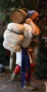
The brigade needed to portage around many waterfalls and rapids.
June 3 ~ Left our campment before sun-rise. … The land on the south shore began to be rocky and steep from the edge of the water. Passed opposite the mouth of the Rideau River, [the waterfall of] 14 to 16 feet high into the Ottawa River. The Rideau may be about 25 yards wide.
About 50 paces from this is a second channel seperated by an Island that extends to the brinck of the fall. Both these channels are of an equal size and in the form of crescents. … When the water is high in the Rideau it is dangerous for canoes to pass near the mouths and on that account they pass on the opposite side of the ottawa.
A mile farther on we came to a large fall called le grand des Chaudieres. The water being high we turned to our right into a long narrow cave surrounded with steep Rocks called La Cave which we ascended upwards of 300 yards to its North Western extremity and there unloaded our canoes; the shore being too steep to haul up the canoes they were brought round light to the ordinary portage at low water and from there carried to the head of the falls.
~ Mr. McLeod and I went to fish, and take a view of the Rapids [while the voyageurs toiled], but to our great surprise caught nothing. …
This fall is the most curious and picturesque in all the grand River. On the North shore the fall is about 10 feet high but on the south side it comes down a steep Rush or Race-way between an Island and the shore and since the country is settled tis here float down the timber. … The rock has several curious crevices in it through which the water pours with a wild appearance.
There are 10 Portages following each other of this name in the space of about 5 miles and some discharges between them (At a décharge, voyageurs unload some cargo, and tow the lighter canoe and return to portage the cargo).
At the uppermost or portages des Chiens, [actually Portage des Chênes or portage of the Oaks], we slept. The mosquitoes intolerable. …
Voyageurs especially disliked portaging.
~ Eight miles farther we came to pointe aux Irroquois or Pointe a la bataille, so called from a party of that nation skirmishing with the Traders in former times here to way-lay them. Came to the Chats [for the large number of raccoons here]. Just below this portage is a pretty farm, formerly a place of trade.
We took but half the cargoe on board for a league [a décharge of 3 miles] during which we voyaged among a number of small Islands divided from one another by various rapidious channels where we had lines [600-yard ropes] to haul up the canoes.
After Gumming the canoe, which is generally done before embarking on a Lake, after passing a portage or rapids], we entered Lac des Chats amongst a cluster of Islands separated by channels of different sizes and strong currents frequent; There is great plenty of pine growing here on each side of us on the ridges. Passed the night at the Fort Ducharge.
June 6 ~ Made the portage [at Ducharge du Fort]. In these channels the water is sometimes swift and narrow and the course winds. … It would be difficult to find the rout at all without an experienced guide for the intricacy of the turns and windings … for the proper channel. The Ottawa River is known to rise and fall to great extreames. Lost half of this day by rain.
~ Next morning we steered a N.E. course to a portage called la Montagne where we carried Goods and Canoe up a steep hill. … Made D’Argy [portage] and reached the Grand Callumet. This portage, the longest in the Ottawa, is 1/2 a League across. Upwards of 300 yards from where we unloaded is a pretty steep ascent. The portage took more than 24 hours — before we cleared it, with what Gumming and mending our canoe…. I presume the portage takes its name from the Indians making use of this stone to make their pipes or calumets of it
June 8 ~ We embarked on the Smooth water above the Grand Callumet with a fair wind which blew straight up the river; … The shore on both sides began to get high and rocky, 100 feet perpendicular, … which it formed a right-angle. It was so narrow that a stone might be case by a good thrower from one shore to the other. This is called les Rochers du Grand Callumet.

Rock tripe or rockweed, which was edible in desperate hungry times.
~ Here I saw for the first time tripe de Roche [rockweed, a kind of moss]–which the men tell me is the last resource men have to subsist upon in the inhospitable regions of the dreary North, and has been Know to keep men alive for months, boiled in water, after having the sand well washed off of it.
Opposite to this marais [swamp] there is a fine sand bank 30-40 feet high near a mile in length which bounds prettily around this point of the Grand Marais in the form of a Crescent. … It is shaded by fine groves of Norway Pine whose stalks grow up 50 feet frequently without branches. At intervals we could see like a large clearing apparently made by fire and which the Canadians would call a Grand-Brulé.
June 9 ~ Left our encampment at the head of the Grand marais where a branch of the Ottawa issues to the southward, … near the entrance of Lac des Chat — making thus an Island of the Grand Calumet portage. This small channel it is said is only passable with small canoes. A league beyond, we saw Fort Coulonges, a sorry hut, situated near the foot of the mountains. Entered Lac Coulonges; … what knots would be on a cord—2 or 3 times the breadth of the River. Lac Coulonges is about 2 leagues long and is near 2 miles broad. At the upper end is a brulé [a burnt area] and another sand bank opposite a grand marais.
This painting shows how canoes were tracked (towed) over waters too shallow for paddling.
~ The Allumets are the next rapids—2 Décharges and a Portage. The portage is 15-20 paces over a pretty steep ascent. This portage would be worth a good deal of money in a flurishing settlement being the best mill seat I ever saw. The water at [the nearest] end is 10-15 feet lower than that above it, so that a canal might be made through the rock to act on machinery. After emptying our canoes of their cargoes, they were hauled round the point of which this portage is the Isthmus. A mile farthur, we came to Lac des Allumets, about 4 miles wide and 9 long from north to south. It is shallow and abounding in shoals, and rocky lands; around it, especially on the East, are very fine Groves of pine. We go now directly towards the chain of Northern mountains as if we meant to cut through them. … Twelve leagues long to the Portages called Les Joachims and so straight withal that you can see as far as the Lake a mile broad.
Source:
 John Macdonell’s journal of the entire voyage is included in “Five Fur Traders of the Northwest.” Minnesota Historical Society Press, (St. Paul, Minnesota, 1965). This diary and another which continues Macdonell’s recollections through 1795 are owned by McGill University of Montreal, Quebec, Canada.
The featured image is “Voyageurs at Dawn” by Francis Lee Hopkins, done in 1781.
Final Thoughts
My novel series used Macdonell’s journal, but placed a younger character to experience the route. Book 1 — Waters Like the Sky, ” Book 2 — “Treacherous Waters” Book 3 — “Uncharted Waters”
Subscribe to this blog and read posts as they are published!
For what I’m researching or quirky discoveries, visit me on Facebook or Instagram (@nlnlnraj): I love your comments.
Book me as a speaker. Use the Contact Me page to find what topics I’m researching.
Ask your library, local school, gift shop to buy copies.
Be a voyageur for an hour—come to one of my presentations.
Consider writing your own chapter—fan fiction—about what else could happen.

